
Service
3D Modeling and Reality Capture for Construction Projects
Aerial photogrammetry, point clouds, orthomosaics, stockpile volumetrics, as-built verification, topographic mapping, and BIM and CAD integration. Six sub-services designed to drop into AutoCAD, Revit, Civil 3D, and BIM 360. Files delivered with a written report and certified where required.
How It Works
Scope the Output Type
Photogrammetry mesh, point cloud, orthomosaic, or volumetric. We confirm the deliverable, the coordinate system, and the level of detail before we fly.
We Fly and Capture
Planned flight path with aerial targets for ground control. Typical capture session runs 30-90 minutes for a 5-acre site.
We Process the Model
Aerial targets and GNSS control points are processed in Pix4D or RealityCapture. Output is reviewed for coverage gaps and quality.
You Get the Files
Mesh, point cloud, or surface model in your preferred format. GeoTIFF, LAS, RCP, E57, LandXML, DWG. Delivered with a written report.
What Is 3D Modeling for Construction?
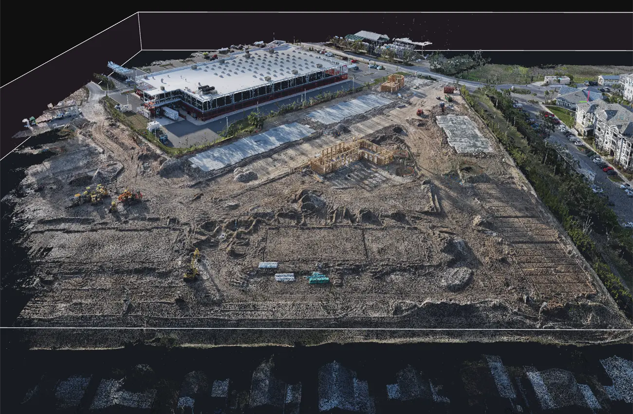
3D modeling for construction uses aerial photogrammetry to build a textured 3D mesh of the project site from hundreds or thousands of overlapping aerial photos. The output is a 3D model, an orthomosaic (a top-down, scaled, north-up image of the entire site), a point cloud, and supporting files.
Across the Florida aerial companies we reviewed, 3D modeling is usually presented as a generic visual deliverable. We are positioning as construction reality capture vs. survey reality capture: the output is structured for engineering, BIM, and survey use, not just pretty 3D visualizations. The model is referenceable, queryable, and audit-ready.
Six Sub-Services
Aerial Photogrammetry and 3D Modeling
Aerial photogrammetry for commercial construction. Orthomosaics, point clouds, textured 3D meshes. 1-3 cm GSD (pixel resolution on the ground).
Point Cloud Generation
Point cloud generation for construction. As-built verification, clash detection, high-density measurement.
Stockpile Volumetrics and Cut-Fill
Stockpile volume calculations and cut-fill analysis for earthwork, aggregates, and material tracking. Cubic yard reports in 24 hours.
As-Built Verification
Comparison of actual site conditions against design surfaces. Identify deviations, document conformance, support pay applications.
Topographic Mapping
CAD-ready topographic mapping with contours, breaklines, and surface models. GeoTIFF + DWG linework for engineers and surveyors.
BIM and CAD Integration
Point clouds and meshes registered to your project coordinate system, ready for Revit, Civil 3D, Navisworks, and BIM 360.
What You Get
Textured 3D Mesh
A 3D mesh of the site with photo texture. Viewable in any 3D viewer. Useful for stakeholder review and marketing visuals.
Orthomosaic
A high-resolution aerial photo of the site, georeferenced and scaled. Drop into CAD, GIS, or any platform that accepts GeoTIFF.
Point Cloud
A high-density point cloud for measurement and dimensional checks. Files in LAS, LAZ, or RCP format. Compatible with AutoCAD, Revit, Civil 3D.
Registration Report
A written report documenting the coordinate system, control points used, registration accuracy, and software compatibility. Suitable for VDC records.
Frequently Asked Questions
What is 3D modeling for construction?
Aerial photogrammetry that produces a 3D model of the project site from hundreds or thousands of overlapping aerial photos. The output is a textured 3D mesh, an orthomosaic, a point cloud, and supporting files.
What formats do you support?
Standard formats: OBJ, FBX, GLTF, LAS, PLY, GeoTIFF, and DXF. Files drop into AutoCAD, Revit, Civil 3D, ArcGIS, QGIS, Trimble Business Center, and most survey and BIM platforms.
How accurate is the model?
1-3 cm ground sampling distance (GSD) with ground control points (GCPs) provides high relative accuracy. We always recommend GCPs on construction sites, and we coordinate with your surveyor or a local PLS for survey-grade deliverables.
Do you offer ground control points?
Yes. We lay out aerial targets and use GNSS receivers to capture their positions. For sub-cm accuracy, we coordinate with your surveyor or a local PLS.
What can the model be used for?
As-built verification, clash detection, quantity takeoffs, stockpile volumetrics, site planning, stakeholder communication, marketing, BIM integration, and dispute resolution.
What is the cost of 3D modeling?
Starting at $850 per model for sites up to 5 acres. Larger sites, multi-day flights, and GCP-heavy projects are quoted separately. The model is the primary deliverable; orthomosaics and stockpile volumetrics can be added.
How long does it take to deliver?
Standard delivery is 5-7 business days from the day of flight. Rush delivery (2-3 business days) is available. Multi-day flights extend the schedule.
What is the difference between photogrammetry and LiDAR?
Photogrammetry uses overlapping photos to build a 3D model from image data. LiDAR uses laser pulses. Photogrammetry is denser, more colorful, and lower-cost. LiDAR penetrates vegetation and is better for tree-covered sites. We do photogrammetry; for LiDAR we coordinate with a partner.
Can the model be integrated with BIM or CAD?
Yes. The point cloud and mesh can be referenced to your project coordinate system and imported into AutoCAD, Revit, Civil 3D, and other BIM/CAD platforms. We provide a registration report with the model.
Are you FAA-certified and insured?
Yes. FAA Part 107 Remote Pilot, OSHA-10, $1M aviation liability, 500+ flight hours. We carry the same certifications and insurance that commercial clients expect.
How much does 3D modeling for construction cost in Florida?
3D modeling for construction in Florida starts at $385 per aerial capture plus processing. Photogrammetry meshes and orthomosaics start at $750 per site. Point cloud generation starts at $850. Topographic mapping with DWG linework starts at $1,200. Most commercial projects spend $1,500 to $5,000 on 3D modeling deliverables over the life of the build.
What is the difference between photogrammetry and point cloud for construction?
Aerial photogrammetry produces a 3D mesh with photo texture from overlapping aerial images. The output looks like a 3D photograph and is best for stakeholder review and visual records. A point cloud is a high-density set of 3D points (millions) generated from the same imagery, suitable for measurement, dimensional checks, and import into CAD or BIM. Most projects use both: the mesh for visual review, the point cloud for measurement.
What software do I need to view a 3D model of my construction site?
Most 3D models of construction sites can be viewed in free tools. Photogrammetry meshes (OBJ, FBX) open in any 3D viewer. Point clouds in LAS or LAZ format open in Autodesk ReCap (free), CloudCompare (free), or QGIS (free). RCP/RCS format for Revit requires Autodesk ReCap Pro. We deliver files in the format your team uses and include a written report documenting the coordinate system and software compatibility.
Contact Us
Tell us about your project. We will confirm fit and recommend a documentation plan.
Contact Us