
Blog · Drone Photogrammetry
Drone Photogrammetry for Commercial Construction in Florida
A working guide to drone photogrammetry for Florida commercial construction. How the capture pipeline works, what the deliverables look like, what they cost, and how to use them in stakeholder presentations, lender packages, and existing-conditions documentation.
Last updated: October 9, 2026
In This Guide
- How Drone Photogrammetry Works: The Capture-to-Deliverable Pipeline
- What You Get: The Standard Deliverable Bundle
- Use Cases: Stakeholder Presentations, Lender Packages, and As-Built Verification
- Real Project Example: 2,161 Acres at Hamlin Town Center
- How Accurate Is Drone Photogrammetry? When It's Right and When It's Not
- Pricing for Drone Photogrammetry in Florida
- What Software You Need (and What You Don't)
- Frequently Asked Questions
How Drone Photogrammetry Works: The Capture-to-Deliverable Pipeline
Drone photogrammetry in commercial construction is a three-stage pipeline. Each stage has its own timing, its own failure modes, and its own cost structure. The project team does not need to manage the pipeline, but understanding the stages makes it clear what the vendor is delivering and why.
Stage 1 is the flight mission. A Part 107-licensed remote pilot flies the site on a planned grid, capturing hundreds to tens of thousands of overlapping aerial photos. The flight plan is tuned to the deliverable. Existing-conditions documentation typically uses 1 to 3 cm per pixel ground sample distance at 100 to 200 feet above ground level. Stakeholder-presentable 3D meshes for sales center experiences use similar ground sample distances but with attention to lighting conditions and texture quality. Topographic mapping with contours uses 3 to 5 cm per pixel at higher altitudes to cover more ground per flight.
Stage 2 is the photogrammetry processing. The raw photos are processed through specialized software (Pix4D, Metashape, RealityCapture, or similar) to align the photos, generate a sparse point cloud, generate a dense point cloud, build a 3D mesh, and apply textures from the original photos. Processing time scales with the size of the dataset. A typical 1 to 5 acre site takes 24 to 48 hours. The 2,161-acre Hamlin Town Center project took 4 to 5 days because the dataset was 45,438 photos.
Stage 3 is the deliverable preparation. The point cloud, mesh, orthomosaic, and surface model are exported in the formats the project team uses. The orthomosaic is georeferenced and exported as both GeoTIFF (for GIS) and JPG (for stakeholder review). The mesh is exported as FBX, OBJ, or glTF depending on the downstream pipeline. The point cloud is exported as LAS or LAZ. The DWG surface model is direct CAD-native. All formats come from the same source data, so they align exactly with no manual stitching.
What You Get: The Standard Deliverable Bundle
A standard commercial drone photogrammetry engagement produces a bundle of files. The exact deliverables depend on the project, but a typical bundle for a Florida commercial project includes:
Textured 3D mesh. The high-value deliverable for stakeholder presentations, sales center experiences, and downstream visualization pipelines. The mesh is the surface of the site, reconstructed from the photogrammetry, with the original aerial photo textures applied. Drop into Unreal Engine, Unity, Twinmotion, or a browser-based viewer. For the 2,161-acre Hamlin Town Center project, the textured mesh was the primary deliverable for a creative studio building an interactive sales experience.
Georeferenced orthomosaic. A north-up, scaled top-down photo of the entire site at a single moment. Drop into AutoCAD as a base layer. Drop into a stakeholder presentation as the visual reference. Use as the visual backdrop for any 2D drawing. Export as both GeoTIFF (for GIS platforms) and JPG (for review and presentation).
Dense point cloud (LAS / LAZ). A 3D point cloud of the site surface, with each point georeferenced. Used for additional measurement, additional modeling in a separate pipeline, and quantitative analysis (volume, slope, drainage). The same point cloud that produces the visual mesh is the data source for stockpile volume calculations and cut/fill analysis.
Digital surface model (DSM). A raster surface of the site, typically delivered as a GeoTIFF. Used for drainage analysis, slope calculations, and as a base layer in GIS platforms (ArcGIS, QGIS, Global Mapper).
Raw photo set with calibration metadata. The original photos with camera calibration, GPS metadata, and processing logs. The archive copy for record retention. Useful if the project team needs to re-process the data later with different settings.
Written deliverable summary. A short report describing the flight mission, the equipment used, the processing pipeline, the deliverable bundle, and any conditions or limitations. Lender and inspector audiences expect this. So does the project team for record retention.
Use Cases: Stakeholder Presentations, Lender Packages, and As-Built Verification
One drone photogrammetry capture produces data for multiple use cases. The most common:
Stakeholder presentations and sales center experiences. The textured 3D mesh, rendered in Unreal Engine, Unity, or a browser-based viewer, gives prospects a navigable view of the site as it currently exists. For projects that are pre-construction or under construction, this is the closest thing to a physical tour without the site actually existing or being accessible. The 2,161-acre Hamlin Town Center project was a creative studio importing the photogrammetry into Unreal Engine 5 for a developer's interactive sales center experience.
Existing-conditions documentation and preconstruction surveys. The orthomosaic and point cloud drop into AutoCAD or Civil 3D as the base layer for site planning, drainage design, utility routing, and grading. The deliverable is engineering-adjacent (1 to 3 cm per pixel ground sample distance) which is appropriate for the planning phase but not survey-grade for construction staking. For projects that require survey-grade accuracy, the photogrammetry is coordinated with a licensed surveyor who provides the legally binding layer on top.
Progress monitoring and lender draw documentation. Recurring captures at the same site, compared over time, produce a defensible photographic record of work-in-place. The 11-month weekly engagement at the Walmart Supercenter in Lady Lake is an example: 48+ weeks of weekly visits, each delivered as a standalone report, all linked to the lender's draw schedule. The photogrammetry produces a progress comparison layer that the GC team uses for internal status and the lender uses for draw confirmation.
Volumetric stockpile calculations and earthwork analysis. The same dense point cloud that produces the visual mesh is the data source for stockpile volumes, cut/fill quantities, and material tracking. The 47 stockpile measurements at Biotech Applied Research in Central Florida were computed directly from a photogrammetry capture. No additional ground survey required.
As-built verification. The orthomosaic at the end of the project is compared to the design drawings to confirm what was built matches what was specified. The DWG surface model is the direct deliverable for engineers comparing as-built to design intent.
Real Project Example: 2,161 Acres at Hamlin Town Center
The largest drone photogrammetry capture we have run to date was a 2,161-acre mission at Hamlin Town Center in Winter Garden, FL, for a creative studio building an interactive 3D sales center experience. The project scope covered the Highway 429 corridor through the site, the adjacent retail frontages, and the surrounding residential neighborhoods.
The flight plan was two-zone: 150 feet AGL over the high-resolution area near the highway and retail frontages where the photogrammetry would be used for hotspot-driven viewpoint rendering in the sales experience, and 300 feet AGL over the outer ring where the geometry was being used for context and orientation rather than for hotspot viewpoints. The center of the site was deliberately omitted because the creative studio was going to full-CGI that area in the final experience.
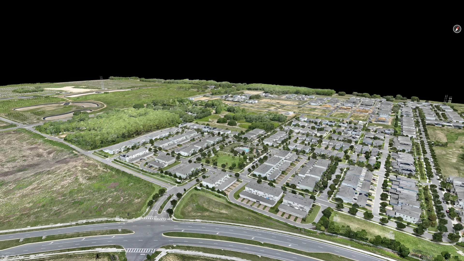
Two days of flying produced 45,438 calibrated photos across 16+ hours of total flight time. The dataset was processed in four to five days into the deliverable bundle: a textured 3D mesh, an orthomosaic, a point cloud, and a digital surface model, all aligned to the same coordinate system. The full case study is at Hamlin Town Center photogrammetry.
The processing pipeline is the same one that runs on smaller projects. The difference is scale. A 1-acre commercial site takes a few hours of processing. A 2,161-acre site takes days. The deliverables come from the same data and align exactly across the whole area, which is the property that makes the photogrammetry useful for the downstream pipeline.
How Accurate Is Drone Photogrammetry? When It's Right and When It's Not
Drone photogrammetry produces visual-quality deliverables with ground sample distances of 1 to 3 cm per pixel at standard flight altitudes. That is appropriate for existing-conditions documentation, preconstruction planning, progress monitoring, stakeholder review, volumetric calculations, and as-built verification. The accuracy is engineering-adjacent, not survey-grade.
Survey-grade accuracy is a different product. Survey-grade deliverables are produced by a Professional Surveyor using ground equipment (total stations, GPS receivers, sometimes drone LiDAR with extensive ground control). The accuracy is sub-centimeter and the deliverables are legally defensible for boundary determination, construction staking, and engineering-grade elevation work. Drone photogrammetry is not a substitute for survey-grade work, but the two are coordinated, not competing.
For projects that need both visual-quality and survey-grade deliverables, the typical workflow is: drone photogrammetry produces the visual and engineering-adjacent layer, and a licensed surveyor provides the survey-grade layer on top. The same control points and the same coordinate system tie the two datasets together. The cost is less than running two separate surveys because the photogrammetry capture provides the spatial framework for the survey-grade work.
For projects that need only one or the other, the choice is simpler. Visual-quality photogrammetry alone is right for stakeholder presentations, sales center experiences, progress monitoring, and as-built visualization. Survey-grade alone is right for construction staking, boundary determination, and engineering-grade elevation work. Most commercial projects need both, and the right vendor coordinates them rather than substituting one for the other.
Pricing for Drone Photogrammetry in Florida
Drone photogrammetry pricing in the Florida market depends on site acreage, deliverable bundle, and processing requirements. As a working range for commercial projects in the Central Florida market:
Standalone photogrammetry for a 1 to 5 acre commercial site: $850 to $2,500. Includes pre-flight planning, on-site flight, processing, and the standard deliverable bundle.
Multi-acre commercial photogrammetry (10 to 100 acres): $2,500 to $10,000 depending on acreage, deliverable bundle, and airspace complexity.
Large-acreage photogrammetry (500+ acres, multi-day flight mission): Quoted per project. The 2,161-acre Hamlin Town Center capture was a multi-day engagement with custom processing for downstream Unreal Engine 5 integration.
Photogrammetry as part of recurring documentation: Starting at $375 per visit when bundled with progress monitoring. Volume discounts apply for multi-month engagements.
Pricing is set per project, not per hour. The pre-flight planning, on-site flight, processing, and deliverable handoff are all included. There are no separate fees for airspace authorization or standard processing. Custom deliverables (Unreal Engine integration, custom volumetric calculations, multi-zone flight plans) are quoted separately.
What Software You Need (and What You Don't)
The standard drone photogrammetry deliverable bundle is designed to work with the software the project team already uses. For most commercial projects, no specialized photogrammetry software is required on the project team side.
AutoCAD and Civil 3D import the DWG surface model directly. The orthomosaic imports as a raster image. The point cloud imports as a referenced layer in AutoCAD 2018+ and Civil 3D, or via ReCap for older versions. The DWG file is engineering-native and works the same as any other base file in the project.
Revit imports the point cloud as a linked geometry file. The orthomosaic imports as a raster image on a planar surface. The mesh imports as a Revit family for schematic use or as a linked geometry for reference. For projects where the photogrammetry is being used as the basis for design, the Revit import is the most direct workflow.
Unreal Engine and Unity import the textured 3D mesh directly. The mesh is the high-value deliverable for stakeholder presentations, sales center experiences, and any interactive visualization. The orthomosaic can be applied as a texture layer if higher resolution is needed for specific viewpoints. The point cloud is rarely imported into game engines because the mesh is more efficient for rendering.
ArcGIS and QGIS import the GeoTIFF orthomosaic, the GeoTIFF DSM, and the LAS point cloud. The standard photogrammetry deliverable bundle is GIS-native and works in any platform that reads GeoTIFF and LAS.
For projects that need a browser-based viewer for stakeholder review (no specialized software required on the reviewer side), the photogrammetry vendor typically hosts a private viewer with the mesh, orthomosaic, and measurement tools. This is the most accessible format for non-technical stakeholders.
Frequently Asked Questions
What is drone photogrammetry in commercial construction?
Drone photogrammetry in commercial construction is the process of capturing hundreds to tens of thousands of overlapping aerial photos of a site with a Part 107-licensed remote pilot, then processing those photos through specialized software to produce a 3D point cloud, a textured 3D mesh, an orthomosaic (geometrically corrected top-down photo), and a digital surface model. The output is engineering-adjacent spatial data the project team can use for existing-conditions documentation, preconstruction planning, progress monitoring, stakeholder review, and as-built verification. Drone photogrammetry is the technical method. Drone survey is the operational service that uses it. The terms get used interchangeably, but the distinction matters when you are scoping a project.
What does drone photogrammetry deliver for a commercial project?
A standard drone photogrammetry deliverable bundle includes: a textured 3D mesh (FBX, OBJ, or glTF for downstream visualization), a georeferenced orthomosaic (north-up, scaled top-down photo, GeoTIFF or JPG), a dense point cloud (LAS or LAZ), a digital surface model (DSM, GeoTIFF), and the raw photo set with calibration metadata. The mesh is the high-value deliverable for stakeholder presentations, sales center experiences, and downstream visualization pipelines. The orthomosaic and point cloud are the engineering-adjacent deliverables that drop into CAD, GIS, and survey workflows. The raw photo set is the archive copy for record retention.
How much does drone photogrammetry cost in Florida?
For a commercial project in the Orlando area, a standalone drone photogrammetry deliverable typically runs $850 to $2,500 depending on site acreage, deliverable bundle, and processing requirements. A single-acre commercial site with a textured mesh + orthomosaic + point cloud runs toward the lower end. A multi-acre project with multi-zone flight plans, custom processing for downstream pipelines (Unreal Engine, Unity, arch-viz), and orthomosaic-only deliverables runs higher. Volume discounts apply for projects that include the photogrammetry capture as part of a recurring documentation engagement rather than a one-off.
How long does drone photogrammetry processing take?
Standard processing for a typical 1 to 5 acre commercial site is 24 to 48 hours. Larger projects like the 2,161-acre Hamlin Town Center capture take 4 to 5 days because the dataset is in the tens of thousands of photos. Tighter turnaround is available for time-sensitive pre-bid or lender draw scenarios. The processing pipeline is GPU-bound, so parallel processing of multiple sites is possible for portfolio projects.
What is the difference between drone photogrammetry and drone mapping?
Drone photogrammetry is the technical method: overlapping photos processed into a 3D model and orthomosaic. Drone mapping is a broader term that covers any drone-based spatial data collection, including photogrammetry, LiDAR, and traditional survey workflows. If your project team searches for "drone mapping" they may be looking for any of those. If they search for "drone photogrammetry" specifically, they are usually looking for the textured 3D mesh and orthomosaic output, not LiDAR or survey-grade deliverables.
How accurate is drone photogrammetry for construction documentation?
Visual-quality drone photogrammetry typically produces ground sample distances (GSD) of 1 to 3 cm per pixel at standard flight altitudes, which is appropriate for existing-conditions documentation, preconstruction planning, progress monitoring, stakeholder review, and as-built verification. The accuracy is not survey-grade (which is sub-centimeter and requires a Professional Surveyor with ground control points). For projects that require engineering-grade elevation or legally defensible boundary determinations, the photogrammetry capture needs to be coordinated with a licensed surveyor who can provide the survey-grade layer on top.
What is drone photogrammetry used for in commercial construction?
The most common uses for drone photogrammetry in commercial construction are: stakeholder presentations and sales center experiences (textured 3D mesh viewed in Unreal Engine or Unity), existing-conditions documentation and preconstruction surveys (orthomosaic and point cloud dropped into AutoCAD or Civil 3D), progress monitoring and lender draw documentation (recurring captures compared over time), volumetric stockpile calculations (cut/fill analysis from the same dense point cloud), and as-built verification (orthomosaic comparison to design drawings). One capture produces data for multiple use cases.
Can drone photogrammetry data be imported into AutoCAD or Revit?
Yes. The point cloud imports into AutoCAD, Civil 3D, Revit, and ReCap as a referenced layer. The orthomosaic imports as a raster image. The mesh imports into Revit as a family or as a linked geometry file. The DWG surface model is direct CAD-native. The standard deliverable bundle is designed to be useful in the same software the project team already uses, without specialized photogrammetry software on the project team side. The processing and file preparation is done on the drone survey vendor side; the project team gets clean, georeferenced files that load into their existing workflow.
Related Services
Drone photogrammetry is often combined with related services on the same site visit. The most common add-ons for Orlando commercial projects:
Orthophoto Mapping
Geometrically corrected full-site orthomosaics for sales center displays, wayfinding directories, planning basemaps, and stakeholder presentations.
As-Built Documentation
Dated, geo-tagged photogrammetry captures for as-built verification and construction record retention.
Volumetric Calculations
Cut and fill volumes, stockpile tonnage, and earthwork quantities from the same dense point cloud that produces the photogrammetry.
Construction Documentation
Aerial photography, existing conditions, preconstruction surveys, and lender documentation bundles.
Planning a Drone Photogrammetry Capture?
Tell us about the site and the deliverable you need. We will confirm fit, recommend a scope, and provide a quote within 48 hours.
Plan a Capture