
Blog · 3D Modeling and Reality Capture
From Volume to Tonnage: How Aerial Stockpile Measurement Becomes a Decision Tool
Drone-based photogrammetry produces per-pile volumes, volume becomes tonnage through field density, and the resulting report is a decision-support artifact, not just numbers on a page.
Last updated: June 11, 2026
In This Guide
- What Is Volume, and What Is Tonnage? (jump to section)
- How Aerial Photogrammetry Produces Per-Pile Volume (jump to section)
- The Missing Piece: Field Density (jump to section)
- Case Study: Citrus Stockpile Tonnage in Central Florida (jump to section)
- What Decisions Does the Report Support? (jump to section)
- When This Is Not the Right Tool (jump to section)
- Frequently Asked Questions (jump to section)
A drone can take beautiful aerial photos of a stockpile, but pretty pictures are not a stockpile measurement. What makes aerial stockpile measurement useful is that the same flight that captures the imagery also produces a per-pile volume in cubic yards, and that volume can be converted to tonnage through a field-derived density. The end result is a report that answers real operational questions: how much material is on site, what size equipment to mobilize, how long the deployment will take, and whether the budget aligns with the actual quantity on the ground.
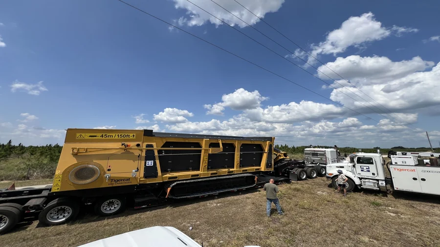
This article walks through how the workflow works, where the math comes from, and what decisions a stockpile volume and tonnage report can actually support. It draws on a real Central Florida project, a 300-acre citrus property where the resulting tonnage report was used to schedule a Tigercat 6040 mobile carbonizer and equipment rental against the actual material quantity on the site.
What Is Volume, and What Is Tonnage?
Volume is the three-dimensional size of the pile, measured in cubic yards or cubic meters. For a stockpile, volume tells you how much space the material is taking up on the ground. Volume comes directly from the aerial data and the photogrammetry processing: the software reconstructs the pile surface from many overlapping images, and the difference between the reconstructed pile surface and the underlying ground surface is the pile volume.
Tonnage is the weight of the material in the pile, measured in tons. Tonnage is not measured directly from the air. Tonnage is derived from volume by multiplying the volume by a density value (weight per unit volume, expressed in pounds or tons per cubic yard). For clean construction aggregate, the density is well known and stable. For organic material like wood chips, brush, or biomass, the density varies with moisture content, particle size, and compaction, and a field-weighted sample is the most accurate way to establish it.
The two are not the same. A pile of wet wood chips weighs far more than the same volume of dry wood chips. A pile of loose brush weighs less than the same volume of compacted brush. Without a density, a volume number is not a tonnage number, and a tonnage number without a defensible density is a guess.
How Aerial Photogrammetry Produces Per-Pile Volume
The flight itself is a standard mapping flight: the aircraft flies a grid pattern over the site at consistent altitude and overlap, capturing many overlapping images of every pile. The processing software (Pix4D, in our workflow) takes those overlapping images, identifies common features between them, and reconstructs a three-dimensional point cloud of the entire site.
Modern mapping aircraft are often RTK-equipped, which means the aircraft receives real-time correction data from a ground reference station and records centimeter-accurate GPS coordinates for each image as it is captured. With RTK, each photo's position is known precisely, the resulting point cloud is georeferenced to a real coordinate system (the citrus project used WGS 84 / UTM zone 17N), and per-pile volume measurements are typically accurate to within 1-2% of the true pile volume without requiring a separate ground control point survey. Without RTK, ground control points must be placed and surveyed on the ground to anchor the data, which adds time and complexity to the field capture.
For stockpile volume, the workflow is then to define the base surface (the ground underneath the pile) and the top surface (the reconstructed pile surface), and the software calculates the difference as the pile volume. The base surface is typically a triangulated mesh derived from the surrounding ground, or a defined plane if the pile sits on a known flat surface. The top surface is the reconstructed pile mesh.
The per-pile output is a table of measurements: pile name, two-dimensional footprint area in square feet, cut volume in cubic yards, fill volume in cubic yards, net volume difference in cubic yards, and an error estimate in cubic yards. The error estimate is important: it tells the client how confident the processing software is in the volume, and it propagates through to the tonnage estimate. On a typical 100-200 yd³ pile, the error estimate is usually well under 2% of the pile volume.
The Missing Piece: Field Density
The volume number from the photogrammetry is accurate. The tonnage number depends entirely on the density value used to convert it. For organic material like brush, wood chips, and biomass, the density is the variable that drives the tonnage estimate, and getting it right is the difference between a planning estimate and a defensible measurement.
The most accurate way to establish density is a field-weighted sample. One representative pile is weighed in person, using a truck scale, a calibrated load cell, or another documented weighing method. The volume of the same pile is then measured from the aerial data, and the weight is divided by the volume to give a density value in pounds per cubic yard.
For example, on a citrus project in Central Florida, one brush pile was field-weighed at approximately 4,070 lbs. The volume of the same pile from the photogrammetry was 135.938 yd³. Dividing the weight by the volume gives a density of about 29.94 lbs/yd³. That density was then applied to the rest of the piles on the property to produce per-pile tonnage estimates. The result was a defensible, methodology-traceable tonnage figure for each pile, not a guess.
When a field-weighted sample is not available, conservative default densities can be used, but the report should be labeled as using planning estimates rather than field-derived densities. The tonnage number is still useful, but the client and the reader should know that the density is an assumption, not a measurement.
Case Study: Citrus Stockpile Tonnage in Central Florida
A 501(c)(3) nonprofit operating in the Central Florida citrus industry needed to understand the volume and weight of woody material across a 300-acre grove. Dead citrus trees, brush, and root wads had accumulated on the property and needed to be processed. The work was pro bono, and the deliverable needed to be more than pretty aerial photos.
The aerial mapping covered the property and produced per-pile volume measurements for 12 named stockpiles plus approximately 35 row measurements, totaling 47 individual measurements across the grove. The measured material surface area was 3.27 acres. Applying a field-derived density of about 29.94 lbs/yd³ to the volumes gave a total of 298 tons of dry material, or approximately 387 tons at a 30% moisture content assumption. The numbers were real, dated, and methodology-traceable.
The full case study, including the four project photos and the per-pile inventory breakdown, is at Citrus Stockpile Volume and Tonnage Mapping for Biotech Applied Research in Central Florida.
What Decisions Does the Report Support?
The citrus case study is the clearest example. The tonnage report enabled three operational decisions that would have been guesses without it:
Equipment rental duration. The nonprofit knew the exact tonnage on the property. They could plan the equipment rental for the duration the work actually required, not for a guess. The result was a tighter rental window and a lower rental cost than they would have committed to on an estimate.
Carbonizer scheduling. The mobile carbonizer deployment was scheduled against the actual tonnage, not a rough estimate. The deployment was sized to the workload and tracked against real progress as the material was processed. The risk of over-deploying the carbonizer (paying for capacity that was not needed) or under-deploying it (running out of time before the material was processed) was materially reduced.
Stakeholder and board reporting. The report gave the project lead a defensible, dated, data-backed record of the project scope to share with the organization's board, its funders, and the citrus community it serves. The numbers were real measurements from a documented methodology, not rough estimates. That is the kind of record that builds credibility with funders and stakeholders.
The same pattern holds for any project where material quantity drives a downstream decision. Construction aggregate inventory, demolition debris estimation, earthwork quantification, biomass processing, environmental cleanup. In each case, the aerial volume plus the field density gives the project team a defensible tonnage number that they can plan and report against.
When This Is Not the Right Tool
Aerial stockpile measurement is not the right tool for every situation. The work is documentation and planning grade, not survey grade or engineering grade. It is not a substitute for a licensed surveyor with survey-grade equipment, and it is not appropriate for work that requires professional certification, stamped engineering calculations, or certified regulatory submissions.
For work that requires a surveyor's stamp, engineering certification, or regulatory-grade precision, a licensed surveyor or engineer should be engaged. The aerial measurement is a complement to that work, not a replacement. It is the right tool when the question is "how much material is here, and what decisions does that enable", and the wrong tool when the question is "what is the certified, regulated, or legally binding answer."

Frequently Asked Questions
What is the difference between volume and tonnage in a stockpile measurement?
Volume is the three-dimensional size of a pile, measured in cubic yards or cubic meters. Tonnage is the weight of the material in the pile, measured in tons. Volume comes directly from the aerial photogrammetry. Tonnage is derived by multiplying the volume by a density value (weight per unit volume). For clean construction aggregate, the density is well-known and the tonnage calculation is straightforward. For organic material like wood chips, brush, or biomass, the density varies with moisture, particle size, and compaction, and a field-weighted sample is the most accurate way to establish it.
How accurate is drone-based stockpile volume measurement?
Drone-based volume measurement using photogrammetry is documentation and planning grade, not survey grade. With an RTK-equipped aircraft recording centimeter-accurate coordinates for each image in flight, the per-pile volumes are typically accurate to within 1-2% of the true volume. Without RTK, the achievable accuracy depends on the ground control point survey, but is usually within a few percent for well-planned projects. The error estimates on individual piles are reported in the deliverable (the XLSX summary for the citrus project showed per-pile cut/fill error estimates in the 0.2-1.8 yd³ range, which is well under 2% of the pile volume). Drone-based measurement is appropriate for operational decisions but is not a substitute for licensed surveyor work.
How is the density value established for organic material like brush or wood chips?
The most accurate way is a field-weighted sample. One representative pile is weighed in person (using a truck scale, a calibrated load cell, or another documented weighing method), and the weight is divided by the volume of the same pile (measured from the aerial data) to derive a density. For the citrus project, one pile was field-weighed at approximately 4,070 lbs, and the volume from the same pile was 135.938 yd³, giving a derived density of about 29.94 lbs/yd³. That density was then applied to the rest of the piles. When a field-weighted sample is not available, conservative default densities can be used but should be labeled as planning estimates.
Can the same volume-to-tonnage workflow be used for construction stockpiles?
Yes. The same drone-based photogrammetry workflow that documents brush and biomass volume on an agricultural or environmental site also documents construction aggregate, soil, demolition debris, and excavation volumes. Construction stockpile volume work is one of the more common applications of aerial mapping for general contractors and site work subcontractors, and the resulting tonnage figures feed directly into pay applications, material tracking, and project closeout.
What does a stockpile volume and tonnage report actually contain?
A complete report typically includes a per-pile inventory with named piles, a per-pile volume in cubic yards, a per-pile area in square feet, a per-pile tonnage estimate using the appropriate density, a per-pile error estimate from the photogrammetry processing, an aggregate total across all piles, a dated orthomosaic of the site with pile locations marked, and a written summary in PDF or other format. The report is the artifact the client uses for scheduling, equipment rental planning, material tracking, and stakeholder reporting.
Is the work survey-grade or engineering-certified?
No. Skyland Pixels produces documentation and planning grade stockpile measurements, not survey-grade or engineering-certified work. The volumes, tonnages, and surface area figures are appropriate for operational planning, internal reporting, equipment scheduling, and inventory. They are not a substitute for work performed by a licensed surveyor with survey-grade equipment, and they should not be used for certified regulatory submissions, stamped engineering calculations, or property boundary disputes. For work that requires professional certification, a licensed surveyor or engineer should be engaged.
Need Stockpile Volumes or Tonnage Reporting?
Tell us about your project. We will confirm fit, recommend a documentation scope, and provide a quote within 48 hours.
Contact Us